Atlantis was a man-made island!
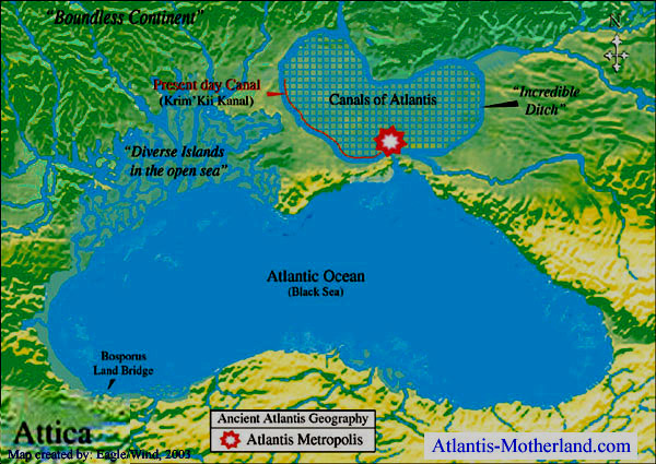
One of the reasons it had been impossible to locate Atlantis was because the island of Atlantis was an island surrounded by land! The Atlantis Motherland book explains that Plato's Atlantis Dialogues state that Atlantis was surrounded by a "boundless continent."
The first Atlantians excavated an "incredible ditch," around the plain, which extended 343 miles, from east to west, and 230 miles, from north to south. The length of the ditch-waterway was an incredible 1,150 miles!
The ditch, or outer canal, was excavated to the depth of 100 feet, and was 607 feet wide. This man-made river carried abundant water to irrigate vast farmlands, and brought water and barges full of produce into the city. A five mile long channel then carried the water from the city into the sea.
The island of Atlantis was excavated, incorporating the natural features of a vast fertile plain, which contained a river delta. This plain was the former Azovian plain, which suddenly sank 11,600 years ago, and became the Sea of Azov.
The vast canal system of Atlantis
Navigable canals were 100 feet wide, and were connected to the ditch at intervals of 11.5 miles, creating a massive criss-crossed transportation and irrigation system (canals on map are not shown to scale).
There were 60,000 farming lots within the extensive canal system! Large barges carried abundant loads of all kinds of fruits, vegetables, timber, metals and minerals into the City of Atlantis.
The map is from page 95 of the Atlantis Motherland book, which reveals the fascinating history of Atlantis in a science-fiction story, which incorporates scientific facts to prove that Atlantis really did exist and that the many ruins, remnants, and magnificent treasures of our precious Motherland Atlantis, are silently waiting to be revealed, beneath the Sea of Azov.
The lost island of Atlantis has been found!
Eleven thousand, six hundred years ago, the island of Atlantis disappeared beneath the Sea of Azov in "one single day and night of misfortune." Suddenly the island of Atlantis was gone! A massive earthquake followed by the Great Atlantis flood was the most destructive event in Human history.
Atlantis was located in southern Ukraine and Krasnodar Kray in southern Russia. The Island of Atlantis sank beneath the Sea of Azov. The former Soviet Union is a very surprising location for Atlantis. The Atlantis Motherland book reveals why the location has been kept secret, and why this well-kept secret has been revealed now.
This map depicts this area as it existed in 9,600 BC. It conforms in every detail to the description of Atlantis recorded in Plato's Atlantis Dialogues. In recent times, the construction of the 300 mile long Krim' Kii Kanal (Shown in red on the map) revealed strong evidence that the ancient ditch followed the same route. Later cultures incorporated and extended remnants of the incredible ditch, which are known today as the Furrow of Osiris.
The Atlantis Motherland book contains geography, bathymetry, hydrology and tectonic maps, photos and diagrams depicting the natural geography and layout of Atlantis. Over 200 full color images vividly portray Solon’s history of Atlantis. An ancient love story, mixed with science field journal investigates the ancient world of our ice age ancestors. Maps and charts show the devastating Earth changes that destroyed Atlantis.
The story of Troy was long considered just a myth, until it was finally discovered. Now it’s time for Atlantis to be discovered, and become part of our history, and honor our beloved ancestors; the mighty Atlantians, and their honorable adversaries, the Hellenes.
|